History
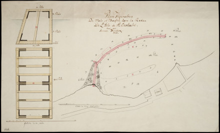

According to Marten Douwes Teenstra, a visitor to the island in 1834, the breakwater was never finished due to cutbacks.During his visit, the structure was in a very dilapidated state and had largely washed away (Teenstra 1837:325).
References
- Marten Douwes Teenstra (1837)
De Nederlandsche West-Indische eilanden in derzelver tegenwoordigen toestand
Amsterdam, C.G. Sulpke - Ruud Stelten (2019)
From Golden Rock to Historic Gem: A Historical Archaeological Analysis of the Maritime Cultural Landscape of St. Eustatius Dutch Caribbean
Leiden: Sidestone Press - Ruud Stelten, Alexandre Hinton (2020)
The SE-504 Shipwreck Site, St. Eustatius Report on the 2018, 2019, and 2020 archaeological research campaigns