History
Background
A number of possible shipwreck sites have been mapped in St Eustatius' Oranje Bay. These sites have been given the designation beginning with SE, an abbreviation of Sint Eustatius, followed by a code number.
Site SE-504 is located 800 metres off the coast in Oranje Bay on the leeward side of Sint Eustatius. The site lies between 18 and 19 metres deep and is neighboured on the southwest side by a coral reef and by sandy seabed on the other sides. The sea bottom is fairly flat at this location but also contains by a few rocky outcrops in the north and centre of the site. The reef and rocky outcrops are overgrown with a variety of corals and sponges. Based on various surveys, the total visible part of the site has been determined to be 61 m long and 13.5 m wide and is oriented roughly north-south.
Among sports divers, site SE-504 is known as the Triple Wreck dive site and is commonly visited.
Surveys at SE-504
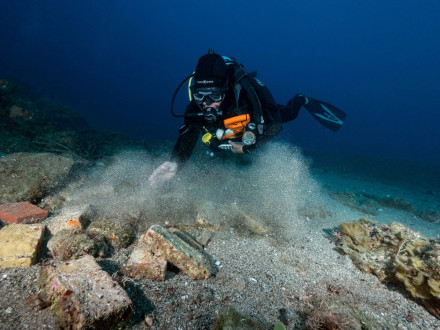
Initial surveys at the sites were conducted by the College of William & Mary in 1986 and later by East Carolina University in 1987 and 1988. Specifically, these involved geophysical surveys with dive inspections. Based on initial information, it was thought at the time that the nearby reef could be a ballast pile in the form of a ship's hull while a pile found further east could be another small area of ballast. Both findings would be refuted by The Shipwreck Survey's survey through field schools conducted between 2018 and 2020. In 2021, a collaboration between the Cultural Heritage Agency of the Netherlands (RCE) and the St Eustatius Center for Archaeological Research (SECAR) conducted an archaeological assessment at the site. The results of the field schools and the assessment are summarised below.
Video recorded during one of the field schools.
In September 2017, hurricanes Irma and Maria wreaked havoc in the Caribbean. Although St Eustatius was largely spared and suffered relatively little damage, the two storms caused rough sea conditions around the island, displacing a lot of sand on the seabed. This revealed a lot of archaeological objects. The finds were immediately reported to both SECAR and the RCE. In the following years, three field schools took place in January of 2018, 2019 and 2020. During these field schools, all artefacts on the seabed were mapped and documented in detail. Based on the field school survey, it was initially thought that this could be a historical shipwreck due to the high concentration of artefacts, including a lot of brick that was interpreted as ballast, as well as finds such as iron nails and other metal parts relevant to ship structures. In addition, personal objects were also found at the site.
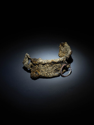
Other metal artefacts found consist of eating utensils and personal practical ornaments such as shoe buckles. Of particular note is part of a copper ankle shackle. This may have been used to restrict the movement of misbehaving sailors or enslaved people, although what it was actually used for cannot be said with certainty. A high concentration of glassware was also found at the time the majority consisting of fragments, but also some complete onion bottles. Many pottery objects were also found, including fragments of clay pipes and several shards of porcelain and stoneware.
Archaeological assessment in 2021
And thus it was concluded after the field schools that the site would be a shipwreck site. Partly for this reason, a team consisting of members of the RCE's programme for International Maritime Heritage (2017-2021), members of SECAR under the guidance of local diving school ScubAqua carried out an archaeological valuation at the site.
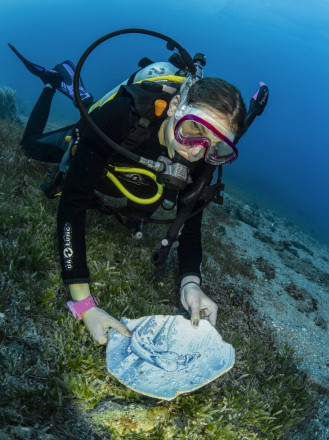
Using airlifts (a kind of sand vacuums), 11 test pits were installed along an east-west oriented survey line in the centre of site SE-504. In the process, as with the field schools in previous years, several finds were discovered, consisting of materials of pottery, glass, metal objects, fragments of clay pipes, stones, wooden objects and even a rubber object. These artefacts mainly date from the eighteenth century, with a few from later centuries. Most likely, these objects were used along the waterfront and were discarded or fell from ships lying at anchor in the roadstead. Some artefacts, such as pottery, glass and barrel rings, indicate ship's inventory or cargo. Personal possessions were found in the form of fragments of clay pipes and a single shoe buckle. Iron parts of masts and rudders, rudder pins, anchors and a sounding board constitute ship's equipment. Ceramic building materials such as roof and floor tiles and bricks may have come from buildings along the coast or possibly served as cargo or ballast.
A single iron cannon may have fallen from a ship, but more likely it was reused as an anchor weight. The survey team determined that the site has medium-high archaeological value. One test pit was left open. This is a pit containing several anchors from which the site derived its colloquial name. These objects are not in danger of being lost further, but offer an opportunity for sports divers to enjoy the site and local history. The area could in the future be managed and monitored by the local marine park (STENAPA) and the ScubAqua diving school.
By educating divers and visitors about the historical significance of the site and conducting proper monitoring, the value of the site could be preserved for future generations while providing a unique diving experience.
In summary, the archaeological evaluation of the SE-504 site revealed an assortment of artefacts reflecting the vibrant trade and historical context of St Eustatius. Despite the lack of a clear shipwreck, the artefacts provide insight into the island's history during its prosperous trading era. By taking protective measures and educating visitors, the historical significance of the site can be preserved while providing an informative and engaging diving opportunity.
Description
Status
The visible part of the site has now been completely mapped and documented. The middle part of the site has now been appreciated. It is likely that many more remains lie beneath the sand. There is still a chance that wooden remains and other shipwreck material do lie hidden under the sand. Future extreme weather may move more sand and expose a larger part of the site.
SE-504 will be continuously monitored.
References
- Kathryn Bequette (1986)
Preliminary Report on the Magnetometer Survey of Oranje and Gallows Bays, St. Eustatius
East Carolina University - Kathryn Bequette (1992)
An Archaeological Reconnaissance of the Anchorage, Seawalls, and Shipwrecks within Oranje Bay, St. Eustatius, Netherlands Antilles
East Carolina University - Ruud Stelten (2019)
From Golden Rock to Historic Gem: A Historical Archaeological Analysis of the Maritime Cultural Landscape of St. Eustatius Dutch Caribbean
Leiden: Sidestone Press - Derksen, L.F., Doesburg, J., De Hoop, R. & M. Manders (Cultural Heritage Agency of the Netherlands) (2024)
RAM 282: Flotsam, jetsam and lost anchors at Statia’s Roads: An archaeological assessment of site SE-504, Oranje Bay, St. Eustatius.
Rapportage Archeologische Monumentenzorg 282 - RCE
RAM 282: Flotsam, jetsam and lost anchors at Statia’s Roads. An archaeological assessment of site SE-504, Oranje Bay, St. Eustatius