History
Rescue excavation
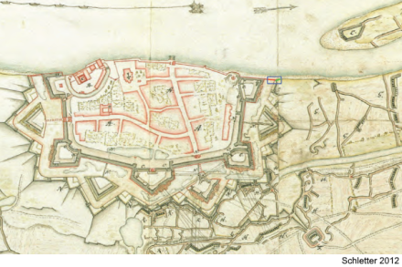
During works at the Rhine dike in the German city of Düsseldorf, remnants of a ship were found in 2009. Within the framework of a rescue excavation of these remains, that were in close proximity to the fortification remains of Kaiserwerth, a flat-bottomed river craft was discovered at the northern corner of the fortification's batardeau (a dam with a sluice gate in a fortification). As substantial masonry remains of the batardeau (see the plan below), a terminus ante quem of 1702 was inferred, associated with the siege of the fortress by allied troops from the Netherlands, Brandenburg and England in the War of the Spanish Succession.
Description
The wreck's cross-section is typical for a type of pram known as nachen in Southern Germany, or more specifically as schnieke in the upper Rhine area.
| Length | 60 ¼ feet (18.4 m) |
|---|---|
| Beam | 11 ½ feet (3.5 m) |
Status
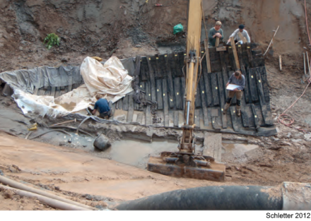
The works on the flood control necessitated a swift recovery of the wreck remains, so that an extensive in situ documentation was impossible.
The ship timbers were transported to a conservation facility at Gottorf Castle in Schleswig for PEG-conservation. In March 2021, the conservation was finalised and the wreck will be re-assembled in the near future at an exhibition area in Düsseldorf (the location of which is to be determined).
References
- Schletter, H.-P. (2009)
Batardeau, Uferbefestigung und ein Plattbodenschiff der frühen Neuzeit in Kaiserwerth
Archäologie im Rheinland 2009
pp 173-175 - Schletter, H.-P. (2012)
Der Kaiserswerther Nachen. Ein archäologischer Beitrag zur Rheinschifffahrt der frühen Neuzeit
Deutsches Schiffahrtsarchiv 35, 2012
pp 13-72